Antartica ( About Grace )

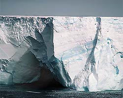
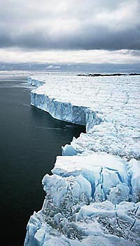
Remote and beautiful, Antarctica is covered by an ice sheet averaging several kilometers in thickness that locks up some 70% of Earth’s fresh water—if it all melted, the oceans would rise about 70 m. Melting of the ice sheet is an obvious concern, since temperatures in the polar regions are increasing at about two-and-a-half times the average rate for Earth. Nevertheless, as recently as 2004, substantial melting of the ice sheet had been dismissed because Antarctica is so cold. Except in the Antarctic Peninsula (which extends north in the direction of South America—see map), the average temperature on the continent is -7° C, and at no time in the year does the temperature rise above zero C, so no melting would occur. In the Antarctic Peninsula (see radar map), the average temperatures can reach -5°, and melting is possible during the two warmest months of the year. Given these low temperatures, only the huge floating ice shelves that extend out from the coast would be threatened by ocean warming, since their undersides are in contact with ocean water. But melting of the shelves (see photo) would not raise sea level, because floating ice displaces its weight, which does not change upon melting. Still, the shelves are believed to play a role in preventing the movement of the rest of the ice sheet towards the ocean, and it is at the coast, where the underside of the shelves ride on ocean water, that a global temperature rise could produce increased melting.

The thickness of Antarctic ice has been measured by satellite-bourne radar. A pulsed radar beam is bounced off the ice, and the travel time from satellite to the surface and back is precisely measured. This method, though, has the disadvantage that the radar beam sweeps only a small area of land in each pass. Moreover, it is difficult to obtain results from regions where the height of the ice changes in the area swept by the radar, typically 15 km or more in diameter. The height of the ice sheet tends to be especially variable near the coast, where melting ice shelves have their largest impact. A very different approach to measuring ice sheet thickness comes from the study of Earth’s gravity. If some of the sheet melts, the thickness of the sheet decreases and so does the acceleration of gravity over it, slightly changing the orbit of a satellite that passes overhead. A satellite in a circular orbit over a region of reduced mass would experience a decreased acceleration of gravity, increase its altitude (since the lower acceleration of gravity would not be sufficient to maintain the circular orbit) and slow down. Once clear of the area of lower gravity, the satellite would speed back up.
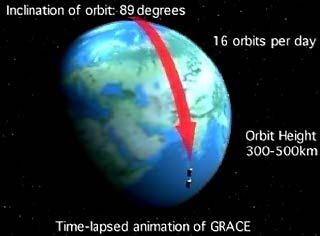
This orbital effect is utilized in the Gravity Recovery and Climate Experiment (GRACE), a joint venture among NASA, the Jet Propulsion Lab (JPL), and the German space agency DLR. GRACE employs two identical satellites flying in formation in the same polar orbit (see drawing) at a separation of 219 km (137 mi). As the pair flies over Antarctica, the first satellite slows down, due to the melting of the ice sheet, so the separation between the two decreases. Later, when both have cleared the continent, the separation returns to its prior value. Since all Antarctic ice contributes to the gravity that the satellites experience, GRACE determines the thickness of the entire ice sheet, as opposed to the limited coverage of the radar studies.
posted by Girish at 5:12 AM
![]()
![]()


0 Comments:
Post a Comment
<< Home